建置緣由Background and Purpose
截至民國114年,全台共有1745條土石流潛勢溪流,全面性進行監測作業有其困難度。為提升災害應變期間的資料蒐集與避災資訊發布效率,
- 民國91年起展開行動式土石流觀測站研發作業。
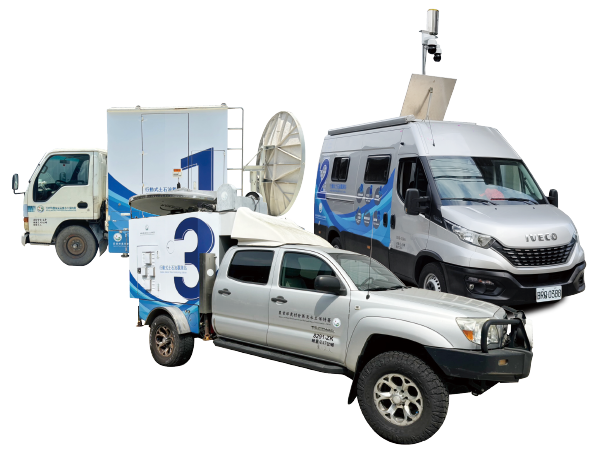
- 民國93年建置第一代行動式土石流觀測站(1號車),以機動化觀測為主軸,透過衛星通訊即時傳輸影像與雨量資料,並具擴充性可加裝觀測儀器。然而,因採無動力載具,須由其他車輛運送,派遣前需預約拖吊,限制其自主性與機動性。
- 民國94年,為提升出勤效率與便利性,農村水保署研發具自主行動能力的第二代行動式土石流觀測站,節省派遣前置作業時間。
- 民國96年精進研發具有自主性與機動性的第三代行動式土石流觀測站(2號車),持續提升自動化功能。
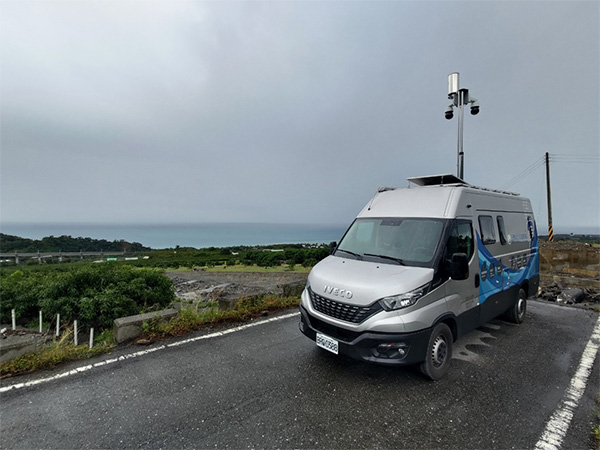
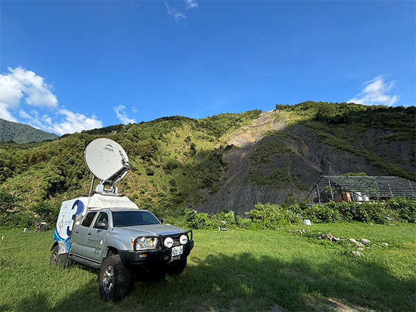
- 民國99年為強化山區觀測能力,第四代行動式觀測站(3號車)採具越野能力及受限地形較小的四輪傳動車輛,並導入電動輔助操作,提升部署效率並減少人力。105年時進行第五代升級作業,於3號車增設環景攝影機,提升環境資料蒐集能力。
- 民國111年時2號車搭載無線攝影機與雷達感測器,輔助大規模崩塌區域移動物體辨識,提升現地施工人員安全性。
- 民國112年進行第六代觀測車(2號車)車體設計與更新,並整合既有功能。
As of 2025 (Year 114 of the Republic of China calendar), there are a total of 1,745 potential debris flow torrens across Taiwan. Comprehensive monitoring of all these streams presents significant challenges.
- To improve data collection and the dissemination of disaster prevention information during emergency response periods, development of mobile debris flow monitoring stations began in 2002.
- In 2004, the first-generation mobile debris flow monitoring station (Vehicle No. 1) was established, focusing on mobility-based observation. It used satellite communication to transmit real-time video and rainfall data and featured expandable instrumentation. However, due to its unpowered carrier design, it required towing by another vehicle, limiting its autonomy and mobility.
- In 2005, to improve deployment efficiency and convenience, the Agency of Rural Development & Soil and Water Conservation developed the second-generation station, which featured self-propelling capabilities, reducing pre-dispatch preparation time.
- In 2007, the third-generation station (Vehicle No. 2) was introduced with enhanced autonomy and mobility, and further improvements in automation functions.
- In 2010, to strengthen monitoring in mountainous regions, the fourth-generation station (Vehicle No. 3) was developed using a four-wheel-drive off-road vehicle capable of operating in rugged terrain. It also introduced electric-assisted operations to improve deployment efficiency and reduce manpower demands. In 2016, the vehicle underwent a fifth-generation upgrade, with a panoramic camera installed on Vehicle No. 3 to enhance environmental data collection capabilities.
- By 2022, Vehicle No. 2 was equipped with wireless cameras and radar sensors to support the identification of moving objects in large-scale landslide areas, thereby improving safety for on-site personnel.
- In 2023, the sixth-generation monitoring vehicle (updated Vehicle No. 2) was redesigned and upgraded with an integrated system combining previous functionalities.
整體架構 Overall structure
1.載具系統Vehicle system
第一代載具採用拖運方式進行部署,自第二代至第六代則採用具備資通訊與電力設備的行動車輛。載具抵達潛勢溪流後,利用油壓系統將車體穩固於地面,確保觀測穩定性與安全性。
The first-generation vehicle was deployed using towing methods, while the second to sixth generations use self-propelled mobile vehicles equipped with ICT and power systems. Upon arrival at a potential debris flow site, the vehicle is stabilized on the ground using a hydraulic system to ensure observation stability and operational safety.
2. 資訊系統Information system
本系統整合多種工業級資訊硬體設備,包括:工業電腦(IPC)、網路型監控主機(NVR)、IP 分享器、網路交換器、遠端電源控制模組(N-POWER)等設備。
上述設備皆安裝於專為車體設計的資訊機櫃中,具抗震功能,並負責控制、資料儲存與網路通訊管理功能。
This system integrates various industrial-grade information hardware, including industrial PCs (IPCs), network video recorders (NVRs), IP routers, network switches, and remote power control modules (N-POWER). All equipment is installed in specially designed shock-resistant information cabinets within the vehicle and is responsible for system control, data storage, and network communication management.
3. 通訊系統Communication system
考量觀測地點常處於通訊不便地區,系統支援:4G 行動網路及VSAT 衛星通訊(採 C Band 頻段,具抗雨衰特性)。
藉由衛星通訊,現場影像與數據可即時回傳農村水保署,利於災情判斷與即時指揮,同時同步儲存於遠端資料庫中,降低資料損毀風險。
Given that observation sites are often in areas with poor connectivity, the system supports both 4G mobile networks and VSAT satellite communication (using the C Band, which is resistant to rain fade). Satellite communication enables real-time transmission of field images and data back to the Agency of Rural Development & Soil and Water Conservation for disaster assessment and real-time command, while simultaneously storing the data in remote databases to reduce the risk of data loss.
4. 觀測系統 Monitoring system
搭載多元感測與影像設備,包括:傾斗式雨量計、地聲檢知器、攝影機(遠距紅外線攝影機、PTZ 可遙控攝影機),PTZ 攝影機可進行遠端平移(Pan)、傾斜(Tilt)、放大(Zoom),提升影像監控靈活性。整體系統可同步收集降雨、振動與現場影像資訊。
The vehicle is equipped with a variety of sensing and imaging devices, including tipping bucket rain gauges, geophones, and cameras (long-range infrared and remotely controlled PTZ cameras). The PTZ cameras can be remotely operated to pan, tilt, and zoom, increasing flexibility in image surveillance. The integrated system can simultaneously collect rainfall, vibration, and on-site image data.
5.電力系統 Power system
為確保連續觀測作業,車輛具備雙電力來源:
(1) 直流供電系統:由電池組提供
(2) 交流供電系統:經電源轉換器供應 110V AC
當電池電量耗盡時,系統會自動啟動發電機補充電力。並結合UPS(不斷電系統)或多工電源整合模組,實現72小時無間斷穩壓供電,保障所有設備正常運作。
(2) 交流供電系統:經電源轉換器供應 110V AC
To ensure uninterrupted monitoring operations, the vehicle is equipped with two power sources:
(1) DC Power System – supplied by a battery pack
(2) AC Power System – provides 110V AC via a power inverter
When the battery runs low, the system automatically activates the generator to replenish power. Combined with an uninterruptible power supply (UPS) or a multi-function power integration module, the system ensures stable, uninterrupted power for up to 72 hours, guaranteeing the continuous operation of all onboard equipment.
(2) AC Power System – provides 110V AC via a power inverter